|
|


 Arabic
 Bengali
 Chinese
 English
 French
 German
 Hebrew
 Hindi
Hindi Italian
 Japanese
 Korean
 Malay
Malay Polish
 Portuguese
 Spanish
 Turkish
 Ukrainian
 Vietnamese
|
WONDERS OF NATURE
Sarez lake. Nature miracle
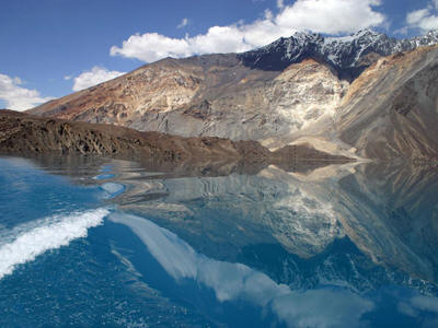
The Murghab River has been flowing for centuries, foaming on waterfalls and rapids, through a steep-walled gorge at the foot of the Pamir Muzkol Range. But on a February night in 1911, the slopes of the ridge shuddered from a powerful earthquake. As a result of the earthquake, a giant rock broke off from the right side of the gorge and collapsed down into the valley, filling it up for eight kilometers. The height of the blockage reached seven hundred meters - this is the height of a 200-story building! Then more than two billion cubic meters of rock fragments collapsed in the Murgab gorge, completely filling up the small village below - the village of Usoy. The Usoi collapse is considered the largest in terms of scale of all that have occurred on the globe. The waters of the river, stopped by the formed natural dam, began to accumulate behind it, filling the gorge. This is how the youngest mountain lake on our planet arose. It grew rapidly, and within six months it flooded the village of Sarez located twenty kilometers above the dam. Its inhabitants, without even having time to harvest from their gardens, abandoned their houses and moved to a new place. And the village hid in the waters of the lake, which was named Sarez in memory of him.
Now it stretches for sixty kilometers in length, and its depth exceeds five hundred meters. The height of the water surface of Sarez above sea level is 3240 meters. Of the world's major reservoirs, few can compete with the Pamir lake in this regard. But the most amazing thing is that below the Murgab dam ... it disappears! From the high dam, no stream of water can be seen below. The waters of the river seep, as if filtered, through the body of the blockage and for seven kilometers below the dam flow underground, in the thickness of pebble deposits at the bottom of the gorge. Only then do they make their way to the surface with abundant springs, which, merging, revive the Murgab. The Sarez region amazes with its severity, lifelessness and some amazing silence. At first, it’s hard to even believe that mountains once collapsed here, waterfalls rumbled and huge pieces of rock rolled down the slopes. But even today, sometimes you can see how a gray cloud suddenly appears on the slopes of Muzkol and, gradually increasing in size, rapidly rolls down. Having flown to the lake, it flops into the abyss, raising a huge column of water. This is another collapse. Only a few minutes later the water surface calms down, and a solemn silence reigns over the lake again. The dry air of the highlands is extremely transparent. The human eye is unable to catch the perspective, and the distant mountains seem as clear and sharp as those standing nearby. The desertedness on the banks of a huge (ninety square kilometers!) Reservoir is also striking. The nearest settlement in the east - the village of Murghab - is located two hundred kilometers up the river. And downstream to the village of Bartang is also no less than one hundred and fifty kilometers. Only rare hunters and geologists appear near the lake in summer. And in winter, the peace of Lake Sarez is disturbed only by the "Bigfoot", legends about which have long been circulating among local Tajiks. And although several expeditions that have been here have not found traces of our wild relative, hunters and shepherds in the Pamirs believe in its existence and talk about encounters with it on the mountain paths of their little-explored region to this day. Sarez is located on the border of two different parts of the Pamirs: the high mountain plateau in the east and the heavily dissected Western Pamirs, or Badakhshan. Badakhshan is a land of high ridges covered with glaciers and turbulent swift rivers that have made their way in narrow deep gorges, similar to the Murgab. In many of them the sun looks only for two or three hours in the middle of the day. And the water in the Badakhshan rivers is sometimes cloudy white, when the stream rushes from under the very glaciers, then transparent bright blue, if along the way the river flows through the lake and leaves sand and clay in it, inherited from melting ice and snow. Only stunted sagebrush and thorny bushes grow on the mountains, pressed to the ground like large gray-green pillows. And in the gardens of villages on the lower terraces of the valleys, apple trees and apricots, grapes and melons grow. In a word, Badakhshan is a land of contrasts: altitude, color and vegetation. And the Eastern Pamir is a plain, only raised to a height of four thousand meters. Here its proud name is fully justified. (Pamir in translation means - "Roof of the World".) Grandiose, 6-7-kilometer high mountains surround the plateau from almost all sides. Clouds filled with moisture do not reach the Pamirs, leaving precipitation on the outer slopes of the ridges, and the air here is so dry that the skin on the lips often cracks on the traveler. In addition, it is extremely transparent, so that when walking through the snowy fields, you have to protect your face with a mask, otherwise sunburn is inevitable. If a random cloud nevertheless spills a rare rain, then its drops evaporate before reaching the ground - all because of the same dryness of the air. In this high-mountainous desert, precipitation is half as much as in the Karakum desert. And the frost in January can be up to minus forty-eight degrees! And in summer the temperature rarely rises above plus ten. It happens that even in June a snowstorm meets the caravan at the pass. In a word, this is the edge of extreme conditions. It is no coincidence that in the vast expanses of the Eastern Pamir, which stretches for four hundred kilometers from north to south and two hundred kilometers from west to east, there are almost no villages. You can drive across the entire plateau along the Pamir Highway, from the Kyzyl-Art Pass to the Shugnan Range, and on the entire XNUMX-kilometer path you will meet only three tiny villages, and the already mentioned village of Murgab. Such "lunar" landscapes: lack of people, lack of water, harsh cold lifelessness - are found in only one other place on our planet - on the Tibetan plateau. No wonder the Eastern Pamirs are called "Tibet in miniature". Of the plants here, only thorny cushion plants and squat bushes of teresken come across - the only fuel for a fire that will help the traveler pass the cold night on the plateau. Animals in this area live mainly on the slopes of the surrounding mountains, where streams flow from glaciers. Marmots and pikas hide in burrows between stone blocks, mighty argali jump from stone to stone along the ridges - large mountain sheep with heavy two-pound horns. The birds of the Pamirs are unusual, many of which are also found in Tibet: the horned lark, the sickle beak, the snow vulture, the Tibetan mountain turkey and the Tibetan raven. And on the plains graze, nibbling rare bunches of dry grass, the owners of these places - shaggy yaks, followed by their worst enemies - lean Tibetan wolves. And woe to the calf that has strayed from the herd - a flock of predators will not miss prey, and soon a huge bearded eagle soaring over the plateau will dive down to complete their bloody feast. If the yak did not exist in the Pamirs, it would certainly have to be invented, because in terms of unpretentiousness and usefulness, only the reindeer of the Far North can be compared with it. The coat of the yak is so long and thick that it does not need any bedding and can easily spend the night on the frozen ground or even in the snow. With a load of one and a half to two hundred kilograms, a powerful animal that gives the highlanders both milk and wool moves along mountain paths with the agility and confidence of a circus tightrope walker. And about yak milk, Tajiks say that it is so thick that "a hare dances on yachikha milk and does not drown." In the cold high mountain desert of the Pamirs, yaks have found extensive, albeit meager, pastures for themselves, where they have practically no competitors. On the banks of the slowly flowing rivers of the Eastern Pamirs, only these unpretentious mountain bulls, accustomed to rarefied air, can easily get food for themselves, and perhaps that is why the only livestock in the transcendental Pamir region is this shaggy giant with a horse's tail, bull's horns and grunting like a pig. In the northern part of the plateau is the highest of the large lakes in Asia - Karakul. "Black Lake" (as its name is translated from the Turkic) is located at an altitude of almost four kilometers above sea level. In terms of area - 364 square kilometers - it is equal to half of Lake Ilmen near Novgorod and four times the area of Sarez. Its brackish and crystal-clear waters do not warm up above twelve degrees even in summer, and seven months a year it is generally covered with ice. Desert expanses of Karakul. Only Indian geese land on its islands in spring, flying north from warmer climes. Once upon a time, ancient trade routes from China to the Mediterranean Sea ran through these places. But we will almost never find descriptions of the Pamirs in the notes of merchants or pilgrims who have been here. Only the Chinese traveler of the XNUMXth century Xuan Jiang dedicated a few lines to the Pamirs: "A terrible cold reigns here, and gusty winds blow. It snows in winter and summer. Neither grain bread nor fruits can grow here." And six centuries later, the tireless Venetian Marco Polo passed along the caravan paths of the Pamirs. In his book under 1270, he wrote: “You climb the highest, they say, place in the world. Twelve days you walk along that plain, it is called the Pamirs, and all the time there is no shelter, no grass, you need to bring food with you. Birds it is not here because it is high and cold. Because of the great cold, the fire is not as bright and not of the same color as in other places, and the food is not cooked so well. " Indeed, it is better to cook meat here in a pressure cooker: after all, in a pot, water boils at such a height already at eighty degrees. Until now, the road connecting the capital of Tajikistan Dushanbe with the center of the Pamirs - Khorog - operates only in the summer. In winter, when the passes are covered with snow, the only way to the Pamirs leads from the Ferghana Valley, from the ancient city of Osh. Through four mountain passes, the Pamir Highway rises in endless serpentines to the "Roof of the World". The last, highest pass Akbaital is located at an altitude of 4655 meters. This is only one and a half hundred meters below Mont Blanc! And on the Taldyk pass, a car on a ten-kilometer stretch turns out to be at an altitude of two thousand meters. The driver here is a heroic profession in the truest sense of the word, but for insurance, cars always go on a flight in two, so that in the event of an accident they will not be left alone in the cold desert. The Osh-Khorog highway is one and a half times longer than the road to the Pamirs from Dushanbe, but it is not covered with snow, and for the Pamirs this is truly the "road of life". It passes by the gloomy Karakul, past the Kuh-i-Lal mine, where a marvelous dark blue stone is mined - lapis lazuli (there are only two such places in the world - here and in Afghanistan), past the hot gushing springs of Garm-Chashma, the village of Bilyand-Kiik, where, according to rumors, they saw a "snowman", and many other wonderful corners of the Pamirs. And only the most precious pearl of this mountainous region - Lake Sarez - is still safely hidden in the heart of the Badakhshan mountains. The path to it today is not easy and difficult. But people again and again make their way to the treasured lake, and not only because of its beauty. Hydrogeologists have long been worried about the fate of Sarez. Imagine what could happen if the water, while peacefully filtering through the Usoi blockage, washes it away and breaks through the XNUMX-meter high dam! A giant water shaft will then rush down the Murba gorge, tearing off blocks of stone from the banks, turning trees, demolishing villages and bridges and destroying everything in its path. A furious water-mud-stone stream - mudflow - will rush down to the confluence of the Murgab with the Pyanj and further, to where the Pyanj and Vakhsh, merging, form the Amu Darya. Dozens of cities and villages will be wiped off the face of the earth. It was the greatest catastrophe of our time! So far, the observations of scientists do not inspire fear: the natural dam behaves calmly. But who knows how things will turn out after another earthquake, which is not uncommon here. And that is why hydrogeols keep watch on Sarez all year round. The pearl of the Pamirs should not become a threat to people. Author: B.Wagner
▪ auroras
Artificial leather for touch emulation
15.04.2024 Petgugu Global cat litter
15.04.2024 The attractiveness of caring men
14.04.2024
▪ Cheap ICs - Signal Generators ▪ Volvo XC40 Recharge electric crossover
▪ site section Batteries, chargers. Article selection ▪ article Protective structures of civil defense. Fundamentals of safe life ▪ article What photographer's name was originally the name of a movie character? Detailed answer ▪ article Translator. Job description ▪ article How to wind a transformer? Encyclopedia of radio electronics and electrical engineering
Home page | Library | Articles | Website map | Site Reviews
www.diagram.com.ua |


 See other articles Section