|
|


 Arabic
 Bengali
 Chinese
 English
 French
 German
 Hebrew
 Hindi
Hindi Italian
 Japanese
 Korean
 Malay
Malay Polish
 Portuguese
 Spanish
 Turkish
 Ukrainian
 Vietnamese
|
BASICS OF SAFE LIFE
Measurement (determination) of distances and areas on the map. Basics of safe life
Directory / Basics of safe life RџSЂRё determining distances on the map use a numerical or linear (Fig. 6.9) and a transverse scale of 1:50 - 000 meters in 1 centimeter.
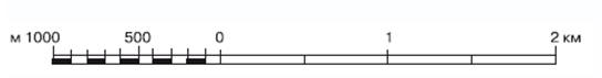
Numerical scale - the scale of the map, expressed as a fraction, the numerator of which is one, and the denominator is a number showing the degree of reduction of terrain lines on the map; the smaller the scale denominator, the larger the map scale. The signature of the numerical scale on the maps is usually accompanied by an indication of the scale value - the distance on the ground (in meters or kilometers), corresponding to one centimeter of the map. The scale value in meters corresponds to the denominator of the numerical scale without the last two zeros. When determining the distance using a numerical scale, the line on the map is measured with a ruler, the result obtained in centimeters is multiplied by the scale value. Linear scale - graphical expression of the numerical scale. It is a straight line divided into certain parts, which are accompanied by labels indicating distances on the ground. A linear scale is used to measure and plot distances on a map. On fig. 6.10 distance between points А и В equal to 1850 m.
Cross scale - a graph (usually on a metal plate) for measuring and plotting distances on a map with the utmost graphical accuracy (0,1 mm). The standard (normal) transverse scale has large divisions equal to 2 cm and small divisions (on the left in the graph) equal to 2 mm. In addition, there are segments on the graph between the vertical and inclined lines, equal to 0,2 mm along the first horizontal line, 0,4 mm along the second, 0,6 mm along the third, etc. Using a standard transverse scale, you can measure and plot distances on a map of any (metric) scale. The distance reading on the transverse scale consists of the sum of the reading based on the graph and the reading of the segment between the vertical and sloping lines. On fig. 6.11 distance between points А и В (at a map scale of 1:100) is equal to 000 m (5500 km + 4 m + 1400 m).
Measuring distances with a caliper. When measuring distance in a straight line, the needles of the compass are set at the end points, then, without changing the solution of the compass, the distance is read off on a linear or transverse scale. In the case when the opening of the compass exceeds the length of the linear or transverse scale, the integer number of kilometers is determined by the squares of the coordinate grid, and the remainder - by the usual scale order. It is convenient to measure broken lines by successively increasing the compass solution with straight segments (Fig. 6.12). The measurement of the lengths of curved lines is carried out by successive deposition of the step of the compass (Fig. 6.13). The step size of the compass depends on the degree of tortuosity of the line, but, as a rule, should not exceed 1 cm. To exclude a systematic error, the step length of the compass, determined by the scale or ruler, should be checked by measuring a kilometer grid line 6-8 cm long.
The length of a winding line measured on a map is always somewhat less than its actual length, since it is not the curved line that is measured, but the chords of individual sections of this curve; therefore, it is necessary to introduce a correction into the results of measurements on the map - the coefficients of increasing distances.
Measuring distances with a curvimeter. By rotating the wheel, the arrow of the curvimeter is set to zero division, and then the wheel is rolled along the measured line with uniform pressure from left to right (or from bottom to top); the resulting reading in centimeters is multiplied by the scale of this map. Determination of distances by rectangular coordinates within one zone can be produced by the formula
where D - line length; x1, and1 - coordinates of the starting point of the straight line; x2, and2 - coordinates of the end point of the line. Determination of areas by the squares of the kilometer grid. The area of the plot is determined by counting whole squares and their shares, estimated by eye. Each square of the kilometer grid corresponds to: on maps of a scale of 1:25 and 000:1 - 50 km2, on maps of scale 1:100 000 - 4 km2, on maps of scale 1:200 000 - 16 km2. Author: Mikhailov L.A.
▪ The effect of alcohol on the human body ▪ Selected documents on emergency situations and disaster medicine in the Russian Federation
Artificial leather for touch emulation
15.04.2024 Petgugu Global cat litter
15.04.2024 The attractiveness of caring men
14.04.2024
▪ Neutrinos have been transformed ▪ Alien star discovered in the Milky Way ▪ Trees help with the city heat
▪ site section Voltage converters, rectifiers, inverters. Article selection ▪ article Every gift is good. Popular expression ▪ article Where were aircraft carriers built from ice? Detailed answer ▪ article Seamstress (tailor). Job description ▪ article Automotive tachometer. Encyclopedia of radio electronics and electrical engineering
Home page | Library | Articles | Website map | Site Reviews
www.diagram.com.ua |
")


 See other articles Section